A 30-unit condominium project on a steep bluff above the San Luis Rey River encountered tension cracks after the first winter rains. The developer had assumed the exposed sandstone would hold without deeper investigation. That assumption cost them a six-month delay and a redesign of the entire foundation system. In Oceanside, the combination of marine terraces, ancient landslide deposits, and seasonal rainfall creates conditions where a standard visual inspection is not enough. We were called in to perform a complete slope failure analysis across the 4-acre site. Using boreholes, inclinometers, and limit-equilibrium software, we identified a deep-seated failure surface at 18 meters. The analysis directly informed the tieback anchor design that stabilized the slope. Without that data, the structure would have been built on moving ground. Our team applies the same rigorous methodology to every Oceanside property, whether it is a single hillside home or a multi-building complex. We combine local geologic knowledge with numerical modeling to deliver defensible results.
A factor of safety of 1.5 under dry conditions can drop to 1.05 when the colluvium reaches full saturation. That is the real risk.
Method and coverage
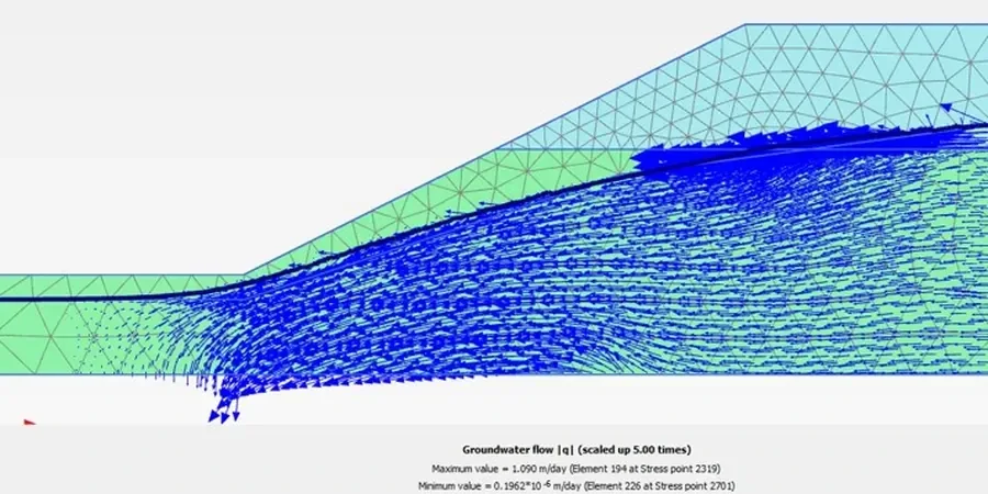
Regional considerations
We mobilize a track-mounted drill rig with continuous sampling capability for Oceanside hillside projects. The rig can reach slopes up to 35 degrees without a crane assist. On site, we install inclinometer casings grouted into the bedrock to monitor movement over time. For one project on a 40-meter coastal bluff, the inclinometer data showed creep at 0.5 mm per month during the dry season, accelerating to 3 mm per month after a 100-year storm. That data triggered a redesign that added 20 soldier piles and a drainage blanket. Without that instrumentation, the failure would have gone unnoticed until the bluff face collapsed. The cost of monitoring is a fraction of the cost of a slope failure.
Standards that apply
ASCE 7-16 Minimum Design Loads and Associated Criteria for Buildings and Other Structures (Chapter 12 – Seismic, Chapter 20 – Site Classification), FHWA-NHI-05-083 (Mechanics of Slope Stability, 2005), ASTM D1586-18 Standard Test Method for Standard Penetration Test (SPT), ASTM D2487-17 Standard Practice for Classification of Soils for Engineering Purposes (Unified Soil Classification System), IBC 2021 International Building Code (Section 1806 – Foundation Investigation)
Complementary services
3D Limit-Equilibrium Modeling
We build detailed 3D models of the slope geometry using LIDAR survey data and borehole logs. The analysis considers multiple failure surfaces, anisotropic strength, and pore-pressure regimes specific to Oceanside's marine terraces.
Instrumented Slope Monitoring
We install inclinometers, piezometers, and surface crack monitors for long-term observation. Data is transmitted wirelessly and reviewed weekly. Alarms trigger when movement exceeds 1 mm/month.
Remediation Design & QA/QC
Based on the analysis, we design drainage systems, soil nail walls, or anchored soldier piles. We provide construction oversight, material testing, and as-built verification to confirm the system meets the required factor of safety.
Typical parameters
Top questions
What is the difference between a standard geotechnical report and a slope failure analysis?
A standard report provides foundation recommendations for a flat site. A slope failure analysis focuses exclusively on the stability of the hillside, including deep-seated failure surfaces, groundwater effects, and seismic loading. It uses specialized software and requires a higher level of subsurface exploration, often to depths of 30 meters or more.
How much does a slope failure analysis cost in Oceanside?
For a typical residential hillside lot (0.5–1 acre), the cost ranges from US$950 to US$2,570. This includes 2–3 borings to 15–20 meters depth, laboratory testing, and a written analysis with recommendations. Larger projects with multiple failure surfaces or complex geology may cost more.
What triggers a slope failure in Oceanside's geology?
The main triggers are winter rainfall saturating the colluvium layer, undercutting of the bluff toe by wave action along the coast, and seismic shaking. The area has ancient landslide deposits that can reactivate when the groundwater table rises. We have documented failures on slopes that were stable for decades after a single wet winter.
How long does a typical slope failure study take?
Field drilling and sampling take 3–5 days depending on access and depth. Laboratory testing adds 2–3 weeks. The numerical modeling and report writing take another 1–2 weeks. Total project duration is usually 4–6 weeks from mobilization to delivery.
Do I need a slope failure analysis if the site has been stable for 20 years?
Yes. Apparent stability can mask slow creep or changes in groundwater conditions. We have analyzed slopes in Oceanside that looked stable but had a factor of safety below 1.3 under saturated conditions. A single wet winter or seismic event can trigger failure. The analysis provides a quantified risk assessment, not a guess.